Memorial / 19A Roundabout
- Justin Erroll Smith
- Sep 22, 2024
- 4 min read

Flying Through Challenges: A Drone Surveyor's Perspective on the Beach Creek Estuary Restoration
In 2021, I had the opportunity to survey a project unlike any other—the restoration of the Beach Creek estuary in Qualicum Beach. This ambitious effort aimed to repair damage caused by waterfront development, including shoreline erosion and compromised fish habitat. The complexity of the landscape, mixed with the intricacies of the project, offered both challenges and immense learning opportunities as I navigated the skies with my drone to document the progress.
Capturing the Restoration from Above
Flying over the site, I could see the stark contrast between the damaged shoreline and the restored areas. The estuary, part of a broader effort to improve waterfront habitats that started back in 1993, was a vital component in enhancing fish passage and re-establishing natural conditions. From the sky, I could visualize how the shoreline had been transformed over the years, thanks to projects like this one.
While aerial views provided crucial data, they also revealed the environmental stresses that had long impacted the shoreline. Bob Weir, the town’s director of engineering, explained that the shoreline had once been an attractive blend of sand and gravel but had deteriorated significantly due to the construction of seawalls. This erosion had wiped out much of the fine sand component in the upper intertidal area, making restoration efforts even more critical.
The Power of Drones in Environmental Monitoring
As a drone surveyor, I witnessed firsthand the challenges that the project team faced. Restoring the estuary was not just about rebuilding nature—it was about navigating obstacles like fish passage and the degrading habitat. By flying low over the creek outlet, I could capture detailed footage of the stream's old storm outfall, which was a significant problem for fish populations. Using high-resolution aerial imagery, I documented the project's goal of creating better refuge for fish and the importance of restoring the creek's natural flow.
This footage became a vital tool for the engineering team, helping them analyze progress and pinpoint areas requiring additional attention. Kevin Dougan, the project engineer, had emphasized the need to enhance the fish habitat while also protecting the waterfront infrastructure. My drone provided unique insights into these dual goals, ensuring that both environmental and infrastructural concerns were being addressed simultaneously.
Adapting to Mother Nature's Curveballs
Flying a drone in such environments comes with its own set of challenges. During a significant storm event in the winter, I had to adapt quickly to turbulent conditions while capturing the damage caused to nearby private properties. The storm’s high winds made flying difficult, but these same conditions were a crucial test for the resilience of the new marine spit and estuary. Monitoring the spit from above as it endured nature’s wrath was one of the most rewarding experiences in this project, and my drone's stability and endurance ensured I could track the storm’s impact effectively.
The drone footage revealed how well the spit’s foundation held up, even against strong waves. It was a real testament to the success of the design, and it reinforced the importance of these types of “soft shore” solutions in coastal environments facing climate change.
Building a Vision of the Future
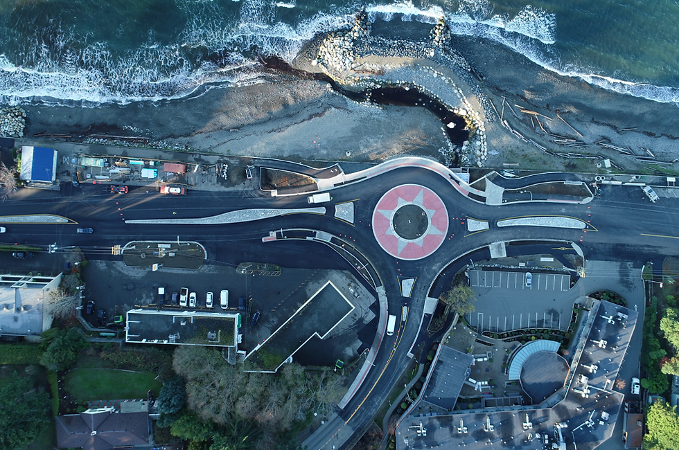
In addition to environmental benefits, the restoration project also included infrastructure improvements, like the construction of a new roundabout. As I flew over the area, it was clear that space constraints posed a challenge for the design team. The drone’s overhead shots allowed us to visualize the tight fit of the roundabout, particularly with the need to incorporate safe passage for pedestrians and cyclists. The cantilevered section out over the foreshore was especially innovative, and my aerial footage helped the team assess its placement and impact on the surrounding environment.
The use of drones became even more critical as the project progressed. Whether it was monitoring sediment traps designed to protect fish populations or inspecting the shoreline’s new profile, drones allowed us to quickly gather data that would have otherwise taken days to compile. From mapping areas to surveying the impacts of climate change and sea-level rise, drones became a vital asset in ensuring that this project achieved its goals.
Overcoming Regulatory Hurdles
Of course, flying in such an ecologically sensitive area required careful coordination. I worked closely with environmental monitors and the project team to ensure that our drone operations adhered to strict regulations. Navigating these rules was sometimes a challenge, but by collaborating with experts, we managed to strike a balance between capturing valuable data and minimizing our environmental footprint.
The restoration of Beach Creek estuary is just one example of how drones can revolutionize the way we approach large-scale environmental projects. By providing real-time data, high-resolution imagery, and the ability to navigate difficult terrain, drones like mine are helping transform the field of environmental engineering.
As a drone surveyor, I find immense satisfaction in being part of projects like these, where technology intersects with nature, ultimately creating a better future for both. While flying above the estuary and watching the restoration unfold, I couldn’t help but feel proud to play a small but essential role in such an impactful project.


Comments